
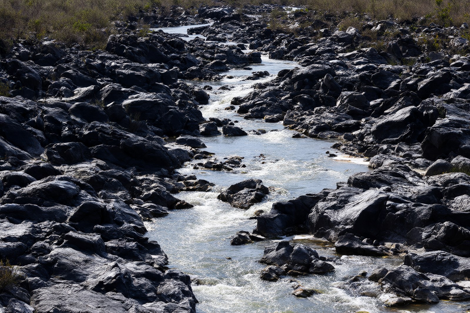
The Wenlan River Wén lán jiāng runs 86.5 kilometres from the hills in the south of the county to the sea in the north, and for most of that distance it is an unremarkable tropical stream averaging about 14.5 cubic metres a second. Four kilometres northeast of the county town, in what is now the eastern edge of the new town, it stops being unremarkable. Here the river crosses a bed of lava left by an eruption that happened somewhere upstream in time rather than in space, and the water comes apart over it into a broad shoal of black and grey rock. This is Bairen Rapids Bǎi rèn tān, and the reason it has a name at all is the noise. The river bends, the current accelerates, the boulders block it, and the water goes over the ledges in a long white rush that in the Ming dynasty was described by the people who lived with it as audible in the county town, ten li away. That sound has its own phrase in the local poetic vocabulary, 百仞滩声 Bǎi rèn tān shēng, the voice of the rapids, and it is one of the eight classical views of Lingao: the full set runs from the shade of the tung trees at Tongxiang and the sunset glow on Penling to the spring flood at the East Bridge, the rain-calling dragon pool, the Piyie spirit stone, the autumn swell at the cape, the trace of a Song exile’s spring, and this. The Ming name for the shoal was different and better. Because the rocks, seen from the bank, looked like a crowd of human heads jostling together, they called it 百人头滩 Bǎi rén tóu tān, the shoal of a hundred heads, and the individual boulders were named for what imagination made of them: two men seated over a chessboard, a group sitting in a ring, a dragon and a tiger locked together. The whole thing is volcanic, which is unusual. Hainan has basalt everywhere, but a rocky rapid on an inland river bed carved by a lava flow is rare enough to be worth the walk on its own, and it explains why the rocks are blocky and angular rather than rounded by water. Three of the other seven classical views are still traceable on the ground: the ridge in the sunset-glow view is the one now called Duowen, the East Bridge of the spring-flood view stood just east of the county town and has been demolished, and the dragon pool of the rain-calling view lies in Dongying town.
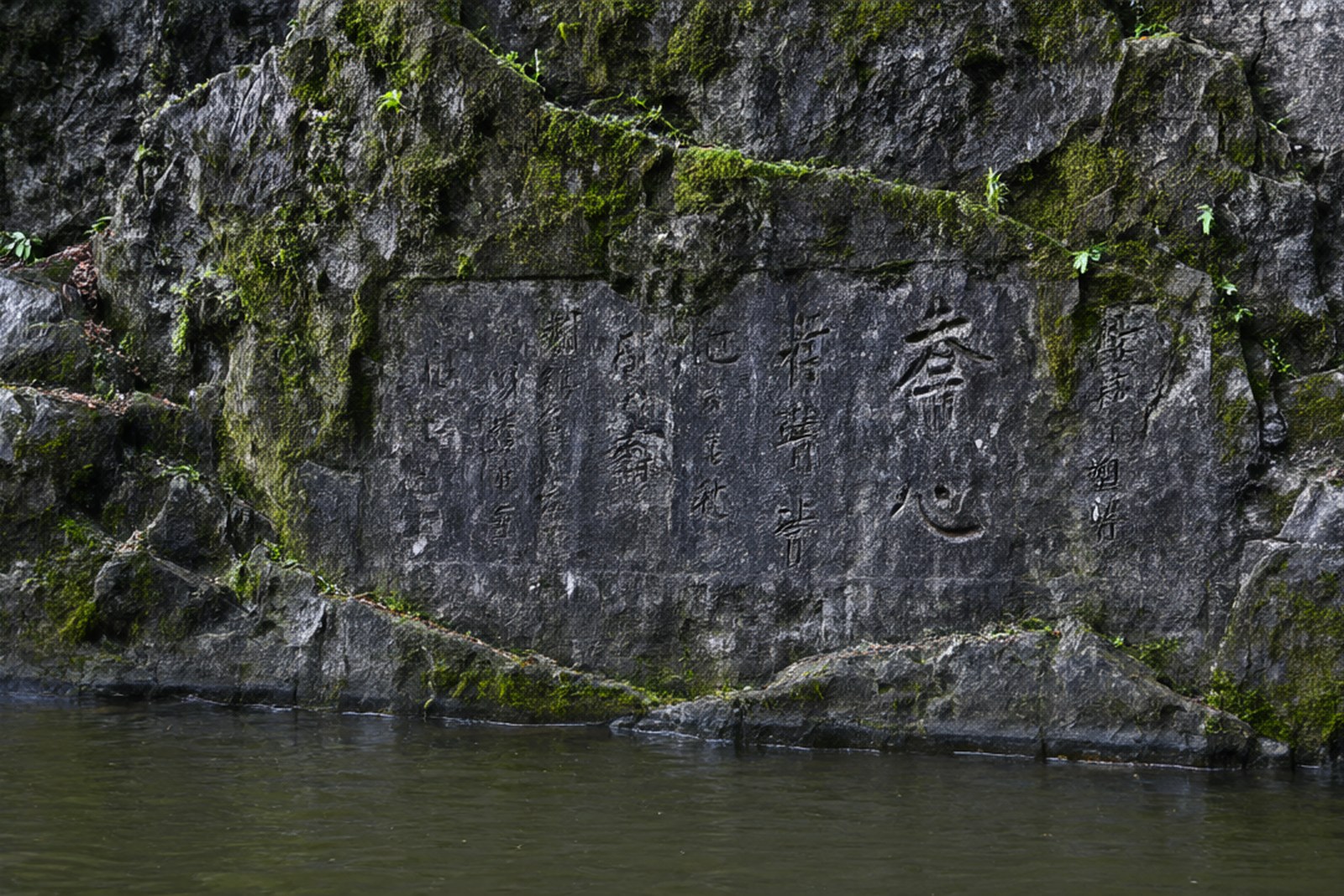
What makes the place more than a geological curiosity is that people wrote on it. The official count, repeated by the provincial gazetteer and the mainstream press, is 18 sites of carved inscription and 106 poems composed and cut here; local writers who grew up with the rapids describe about thirty blocks of poetry and calligraphy; and a Hainan Daily reporter who went looking for them in 2015 came back with fewer than ten, the rest having gone into the river, into the fields or into private hands. All three numbers are true of different things, which is itself the story: this was a public archive of stone, and a river is a poor filing cabinet. The most famous inscription is the name of the place in three characters, cut by Wang Zuo Wáng Zuǒ, the Ming poet of the county, with a date in one travel note that is impossible, since it puts him at work in 1556 and he died in 1512, so the honest label is simply Ming. Wang Zuo also left a poem about riding out of the east gate to look for wild flowers, finding the rapids instead, and sitting down with a cup beside the fast water. A Ming official named Wang Jinshang, from Meiao village in Bolian town, wrote the lines that everyone quotes about mist flying up into nothing, a wide flood of water striking the stones, spray breaking into a thousand flowers round as jade, and a waterfall roaring through the gullies like thunder. A Qing writer named Zhong Yuanpu asked whether the river had been sent down from the Milky Way and where its roots in the clouds might be. And near the middle of the shoal there is a set of four characters, 临江天濑 Lín jiāng tiān lài, meaning something like the heavenly rapids by the river, which one account dates to the spring of the first year of Xuantong, in 1909, and another to the third year, in 1911, so the safe attribution is the Xuantong period, with the writing credited by tradition to a man named Wen Heting. In 2009 the whole group of inscriptions was listed as a provincial cultural relic protection unit, which is the site’s only formal status.
The reason the inscriptions disappear is the reason they are memorable. The Wenlan rises and falls, and as it does, the carved rock goes under and comes back. Poems that were readable in March are four feet underwater in August and dry again in December. Writers in Hainan have made a small literature out of this, calling the carvings stone poems collected by running water and pointing out that when the water is high the verse is inside the river and when it is low the verse dries out and waits to be read, so that the poems keep their own calendar. Hainan Daily went further and claimed that this habit, of putting poetry on stone and then letting the river take it, is unique to this island. The claim is not the kind of thing that can be proved, but standing on a boulder in the middle of the shoal with the water loud in both ears, it does not feel like a stretch. What is certain is that there is no visitor centre, no railing and no interpretive panel standing between you and the text. You read these poems by finding them, and you find them by knowing roughly where the water has been.
The other long shadow over the shoal is Tian Han Tián Hàn, the playwright and lyricist who visited in the summer of 1962 and wrote a poem about it that the county still prints. He came with a whip reined in at the head of the rapids, he wrote, with layered cliffs and flying water making the noise of ten thousand thunders; the river widens here, and one day there will be a firm dam and a power station. Two Hainan newspapers print the middle of the poem differently, one naming the river in full and putting the dam in the future tense and the other shortening the name and putting the dam in the perfect tense, so quote it with that warning attached. The line is startling in hindsight, because that is exactly what happened, twice over and with two very different outcomes. In 2020 and 2021 a hydropower station upstream at Baiyantan dammed and diverted water in breach of its obligations, and the ecological flow in the reach below fell so far that the rapids effectively stopped running, taking the sound and the ecosystem with it. In June 2021 the county procuratorate found the problem while carrying out its duties, opened a case in July, and issued a pre-litigation recommendation to the county water bureau; that October, on the county government’s instruction, several departments acted together to shut the station’s intake and force it to stop and rectify, and the water came back up to its natural level. The sound of the rapids returned, and the 「百仞滩声」 that the Ming poets listened to was once again audible in a county town that has grown considerably since they wrote. It is a rare thing to be able to point at a piece of scenery and say that a legal filing saved it, and it makes this shoal a better place to think about the relationship between tourism and the river than any amount of signage could.
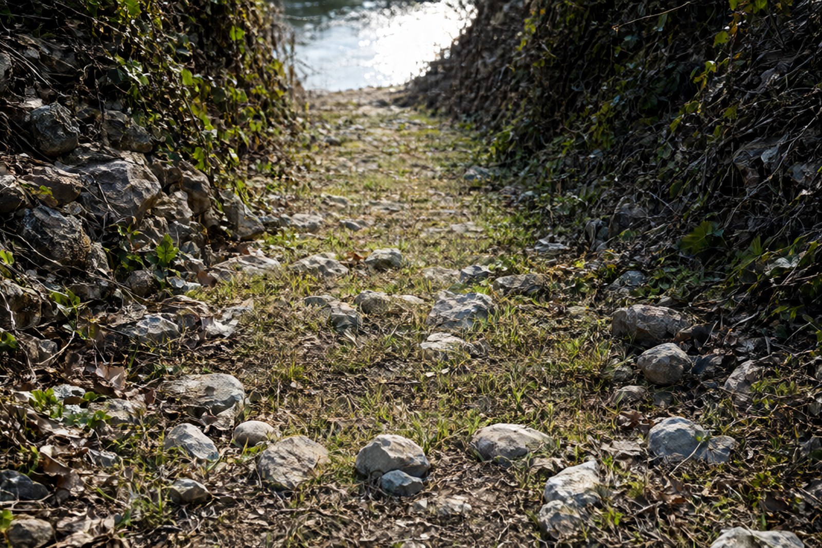
The newest layer is concrete, and it is worth knowing what you are looking at. In November 2021 the county began a project to rebuild the sluice and weir at Bairen Rapids on the Wenlan, at a cost of about 49.87 million yuan, designed around five ideas it lists as flood control, ecology, landscape, history and humanity, with river channel work, ecologically treated revetments and landscape bridges, and the stated aim of bringing back the experience of listening to the rapids. The work passed its unit inspections and its completion inspection between April and June 2024 and is now in use. That means the water you see is partly managed water, which is the price of getting the sound back, and the structures you see at the downstream end of the reach are new. Everything else about the site is old and unimproved. There is no ticket, no gate, no opening and closing time, and no ranger; the path in from the road is unmaintained and green with moss, the rocks are loose underfoot, and the little concrete footbridge on the approach carries a sheet-metal notice limiting it to no more than five people at once. Visitor write-ups are blunt about this, one of them saying flatly that it is not a scenic area at all, that the track is overgrown and lined with loose stone and that it is not a safe place to bring children. Take the warning seriously, wear shoes with grip, do not come alone, and do not come at all after heavy rain, when the river is fast and the rocks are slick. Come in the wet season from May to October if you want the rapids at full voice, in the dry months if you want to read the carvings, and in the late afternoon for the light on the water; photographers are advised to be there before ten in the morning or after four, and for this particular subject the later hour is the better one. That seasonal rule is an inference rather than a documented claim, since no official text states outright that the rapids are loudest in the rains, but the river is a seasonal one and the behaviour of a rocky bed under a monsoon is not mysterious.
Practicalities
Tickets. There is no ticket and no charge. The rapids are listed as free to enter by every source that mentions a price, and there is no gate, booth or collector anywhere on the site. One travel platform adds a note about other paid items inside the area, but no such item could be identified and nothing on the ground suggests one exists. Visit expecting a completely uncommercialised river bank.
Opening hours. Open all day, every day, without exception in any source, because there is nothing to open. The practical hours are set by the light and the water: the useful window is between about seven in the morning and dusk, the recommended photography hours are before ten and after four, and the whole site should be avoided in the dark, since the access path is unlit, uneven and partly overgrown. Allow an hour for the walk in, the shoal and the walk back.
Closing day. No closing day is reported, and no closing day exists in the ordinary sense. This is not a managed attraction and there is no weekly rest day, no seasonal closure and no staff rota. The one thing that does close is the river: after heavy rain the shoal can be dangerous and effectively inaccessible, and it is worth asking locally about the water level before you commit to the walk in.
Getting there. Drive and navigate to Bairen Rapids if you have a car, which is the simplest route. On foot, the documented approach is from the south side of the Wenlan Culture Park: take the small path beside the archway at the southern edge of the park, about 400 metres along it, and cross the small bridge to reach the rapids. A more detailed version of those directions, from a visitor, runs about 200 metres along the path beside the southernmost archway, straight on at the fork rather than turning, another 150 metres to a marker reading Bairen Rapids Stone Inscriptions, Hainan Provincial Cultural Relic Protection, and then a small bridge about 50 metres further on, the one with the sheet-metal notice about five people, which puts you at the water. City buses 4, 5, 6, 7, 10 and 50A have been listed by a community note as serving the area, but this is not an official route announcement and the numbers should be checked locally. No guide service, no official telephone number and no booking system is published.
What you are really visiting here is an archive with a bad roof. A county full of scholars chose a live river as the place to write down what they thought, and the river has spent four hundred years editing them, drowning some and revealing others, carrying a few away entirely. The best hour to see it is late afternoon in the dry season, when the water is low enough to pick your way out onto the shoal and the carved characters are warm with light and easy to read. Then stay until the sun goes down and listen, because the point of the place is not the stones. It is that a Ming poet named the noise, a twentieth-century playwright predicted the dam, a twenty-first-century prosecutor turned the water back on, and you can stand on the same black rock and hear all three of them at once. Bring a pair of shoes you do not mind soaking and leave the tripod at home; the boulders are more stable than they look when they are dry, and less stable than they look when they are not. If the water is up and the crossing looks doubtful, walk the bank instead and settle for the sound, which is the part the county has been writing about since the Ming.
Getting there: Bairen Rapids lie on the lower Wenlan River about 4 km northeast of Lingao county town, in the eastern part of the new town area; drive and navigate to the name, or walk in about 400 metres from the path beside the southern archway of the Wenlan Culture Park and cross the small bridge, and there is no ticket, no fixed hours, no guide service and no official telephone number.